Solar energy in progress and future research trends
Topographic effects
|
90* 60' 50" 40' 30* 20* 10* N 0* S 10* 20* 30* 40" 50*60* 90 |
Topography is the expression of the earth’s surface directional vision, height and surface features Although the surface albedo is different than the planetary albedo it makes an important contribution to the planetary albedo. The cloud distribution is the major dominant influence on the earth surface incident solar energy. Since the albedo is a dominant factor in different meteorological and atmospheric events,
|
|
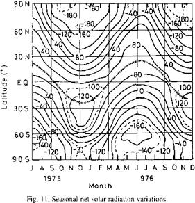
its influence on the availability of solar radiation has an unquestionable significance. Hence, the calculation of solar energy potential at a location is directly related to albedo events, and therefore, the characteristics of surface features become important. In general, the albedo and hence the solar radiation energy potential at any location is dependent on the following topographic and morphologic factors.
1. the type of surface,
2. the solar elevation and the geometry of the surface relative to the sun, and
3. the spectral distribution of the solar radiation and the spectral reflection.
Table 3 indicates different surface albedo values with the least value for calm sea surface as 2%, and the maximum at the fresh snow surface reaching up to 80% albedo value.
In general, forests and wet surfaces have low, but snow - covered surfaces and deserts have high albedo values. On the other hand, the surface albedo is also a function of the spectral reflectivity of the surface.
In all the above discussions, the earth is assumed to have a perfect spherical shape, but in reality, it is slightly distorted by rotation and the distortion amount is approximately 0.3% of the earth’s mean radius with the equatorial radius being greater than the polar radius. Additionally, the earth surface is also rough with heights and lows. The mean sea surface level has been obtained by long-term observations at coastal stations around the world. With reference to the mean sea level, the surface of the continents has a mean altitude of 840 m, whilst the mean depth of the ocean is 3800 m, which implies that the average height of the earth’s crust is 2440 m below sea level. The most extensive topographic feature is the continental slope or escarpment. Only 11% of the land area is above 2000 m elevation.